5. Spectral Information — Bands, Bit Depth and Dynamic Range Adjustment Bands
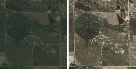
Each imaging band measures different wavelengths of light. Most commercial optical imaging satellites capture panchromatic (pan, viewed as monochromatic gray scale) imagery at higher resolution and four multispectral (MS) bands—red, green, blue and infrared—at one-fourth the resolution to support a colorization process called pan-sharpening. Notable exceptions to this include WorldView-1 (pan only); WorldView-2 (pan + eight MS bands instead of the typical four MS bands); and RapidEye, which acquires five MS bands but no pan imagery (see table on page 1).
The most common format for typical users is true or natural color, which is three-band RGB (red, green, blue) pansharpened, as most users desire the combination of color and spatial detail. However, advanced users performing classification or analysis generally prefer four-band imagery, because the infrared band is helpful for vegetation analysis (see “Project Example: Classification Maps on page 2”).
Smaller file size used to be considered an advantage of pan imagery, but with increased computing capability, that has become less of a constraint. Pan imagery remains the preferred format for htt generation from stereo pairs. When importing multiband imagery, different combinations can be selected. Four-band imagery 3-2-1 typically corresponds to true/natural color, whereas 4-3-2 represents false color/infrared.

Project Example:
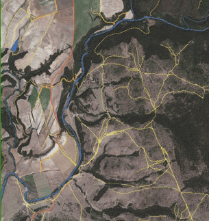
Vector extraction from imagery allows roads, hydrology, building footprints and other features to be mapped faster and less expensively than traditional ground surveys to create new maps or update/ correct existing maps. The resulting accurate, up-to-date base data then are used to support applications such as Internet mapping portals and handheld Global Positioning System devices.
Unlike classification maps, which require multispectral imagery to emphasize the spectral properties of various features, feature extraction is based on spatial properties—size and shape of objects—so pan imagery can be used. Color imagery, however, makes it easier to identify certain features, such as water, paved vs. unpaved roads, etc.

Despite advancements with machine learning and object-based image analysis, features such as roads and building footprints still often are captured via manual heads-up digitizing. Computer-aided design (CAD) applications typically work best with 8-bit imagery, with a contrast stretch already applied to the imagery. Especially in areas of interest (AOIs) of high relief or those comprising more than one scene, imagery should be orthorectified prior to feature extraction.
Wavelet compressed file formats, such as ECW, MrSID and JPEG 2000, help facilitate file transfer across multiple production/quality assurance teams. Otherwise, it may help to tile GeoTiff imagery, as some CAD programs are limited in their ability to work with large raster files. Whenever possible, seasonality consideration should be given to AOIs, as leaf-off imagery yields better feature visibility.
Bit Depth
Beginning with GeoEye’s IKONOS satellite, all leading high resolution commercial imaging satellites capture 11-bit imagery, meaning a maximum of 2,048 digital numbers (DNs) per band instead of the earlier 8-bit/256 levels. RapidEye’s satellite constellation and Astrium’s Pléiades satellite offer the additional advantage of collecting 12-bit imagery. Improved bit depth aids the ability to discern detail in an image’s brightest and darkest (shadow) areas.
Most computers require data in 8-bit format, so an 11- or 12-bit image can have the color table (DNs) downsampled to 8-bit or upsampled to 16-bit. In this case, the four or five unused bit locations are filled with zeros, creating a 16-bit file format but not a true 16-bit image. Imagery used for classification or analysis, or that which must be tonally balanced, always should be ordered in 16-bit format. For many users, however, there’s convenience to using 8-bit imagery— smaller file sizes and no software compatibility issues.
Dynamic Range Adjustment
When delivering 8-bit imagery, high-resolution satellite operators typically will perform an automated process to adjust contrast and brightness. Dynamic range adjustment (DRA) offers a time savings for “load-and-go” imagery, so a user can avoid running a manual adjustment. This is prone to fail in certain areas, however, such as a desert where the color spectrum isn’t balanced. In such instances, a manual adjustment will yield better results. Manual contrast adjustment also tends to work better with pan imagery.
6. Projection
Although many programs now perform “on-the-fly” reprojections, ordering imagery in the same projection as other project data being used is still desirable. Stereo imagery for DEM generation often will be ordered as epipolar; however, a Universal Transverse Mercator (UTM) ortho later can be output. Because satellite operators offer a limited selection of projections, supporting a region-specific datum may require a custom reprojection.
7. Resampling Method
Cubic convolution typically is the default resampling method for Earth imagery, but the enhanced kernel—a hybrid of cubic convolution—is recommended for DigitalGlobe’s pan-sharpened products. For research applications, where image data may be converted to radiance values, nearest-neighbor resampling offers the advantage of not introducing any new values to the imagery, but it can introduce what appear to be geometric and color defects. Most imagery users wouldn’t be satisfied with the appearance of imagery processed with the nearest-neighbor method.
